Elk gekleurd gebied op de kaart heeft een eigen risiconiveau. Hieronder zie je per gebied waarvoor het niveau is afgegeven.
Niveau 2
Matige kans
Noord-Italië
In Noord-Italië worden zware onweersbuien verwacht met kans op hagel, zware windstoten en hevige regenval. De buien kunnen zich in de middag en avond ontwikkelen en lokaal voor overlast zorgen.
Grote hagel
Zware windstoten
Extreme neerslag
Niveau 2
Matige kans
Zuid-Duitsland, Noordwest-Polen
In Zuid-Duitsland en Noordwest-Polen kunnen zware onweersbuien ontstaan met vooral kans op zware windstoten. De buien kunnen zich organiseren tot een squall line, vooral in de avond.
Zware windstoten
Niveau 1
NL
Kleine kans
Frankrijk, Duitsland, Polen
In Duitsland en Polen kunnen zware onweersbuien ontstaan met kans op grote hagel en zware windstoten. Er is ook kans op zware regenval en een geïsoleerde tornado. De buien kunnen zich organiseren tot een squall line, vooral in de avond.
Grote hagel
Zware windstoten
Extreme neerslag
Tornado's
Niveau 1
Kleine kans
Oost-Spanje
In Oost-Spanje is er kans op geïsoleerde onweersbuien met hagel en windstoten. De kans op buien is klein door een sterke cap, maar als ze ontstaan, kunnen ze lokaal voor overlast zorgen.
Grote hagel
Zware windstoten
Onweer
50% kans op onweer
West-Rusland
Onweer
50% kans op onweer
Noord-Turkije, Georgië, Armenië
Onweer
NL
50% kans op onweer
Zuid-Frankrijk, Duitsland, Zweden
Onweer
NL
15% kans op onweer
Zuid-Spanje, Frankrijk, Duitsland, Polen, Zweden
Onweer
15% kans op onweer
Noord-Turkije, Georgië, Armenië
Onweer
15% kans op onweer
West-Rusland
Onweer
15% kans op onweer
Zuid-Schotland
Deze samenvatting is automatisch gegenereerd op basis van de originele ESTOFEX-outlook en kan afwijken van de bron. Raadpleeg de volledige outlook voor het volledige beeld.
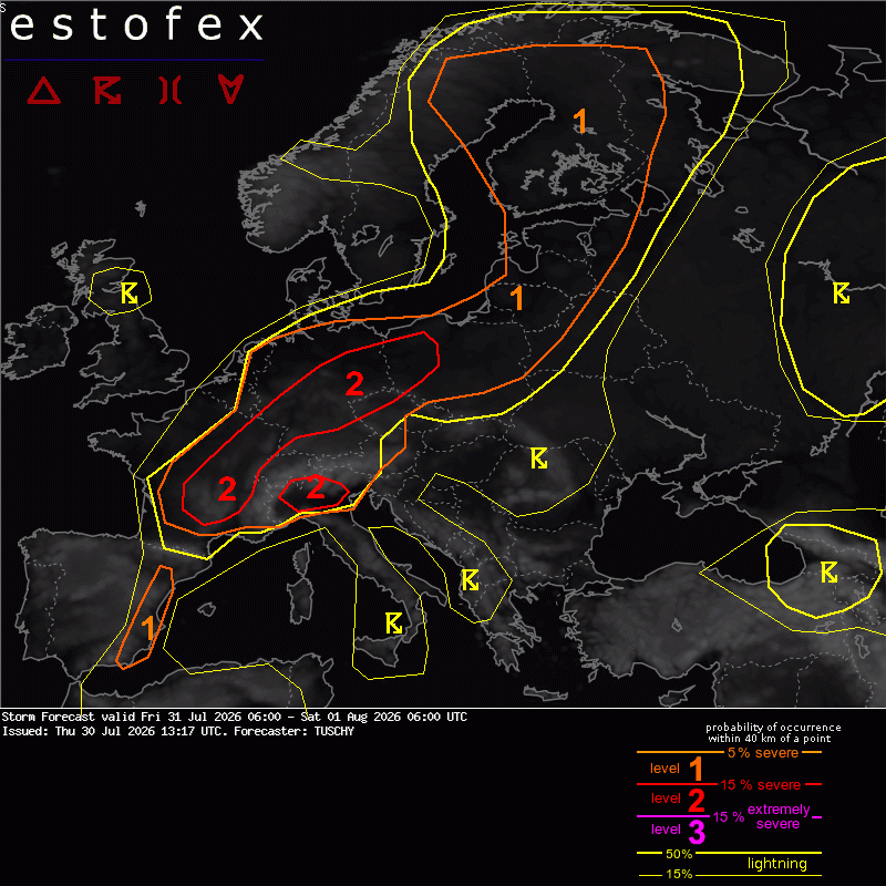
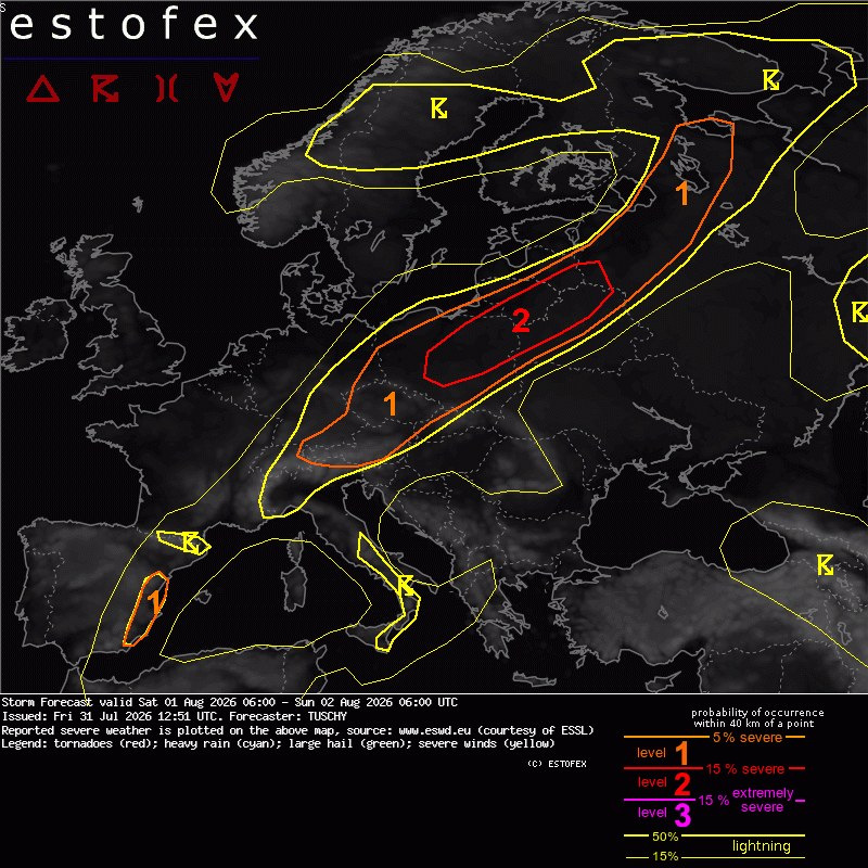
A level 2 was issued for parts of CNTRL/E France mainly for very large hail, severe gusts and heavy rain.
A level 2 was issued for parts of N Italy mainly for hail, damaging gusts and heavy rain.
A level 2 was issued for parts of Germany into NW Poland mainly for damaging gusts.
A level 1 surrounds all level 2 areas for similar hazards with lowered probabilities (hail, gusts, heavy rain). An isolated tornado is possible over NW Germany and over Finland.
A level 1 was issued for E Spain mainly for isolated hail and gusts.
SYNOPSIS
A static pattern features a NE ward aligned ridge from S towards E Europe, which faces a trough over NW Europe. A strong frontal zone covers most of W to NE Europe and is accompanied by a wavy frontal boundary. Progressive short waves, which cross this boundary serve as foci for organized DMC activity from France to Finland.
DISCUSSION
!! We issued broad level areas to account for uncertainties in self induced long-lived and cold pool driven convection. Some areas see less activity, whereas others could see higher severe probabilities than currently highlighted (e.g. Switzerland to S Germany and NW Germany). Nowcast will be important for today's event as only marginal shifts in activity could result in substantial shifts of severe maxima. !!
... France to Poland ...
A sheared short wave crosses the area from SW to NE with the northern lobe of energy remaining more progressive. IFS-ENS has at least 3 focused areas with concentrated IFS-ENS member clouds for transient/weak surface vortices, which spin up along the frontal boundary - one near the Massif Central, another one over Germany and a third one over Poland.
Over CNTRL/E France, most areas still see an ongoing BL moisture recovery behind yesterday's convection, but 500-1000 J/kg MUCAPE should be available from E France to Switzerland into S Germany with up to 2500 J/kg MUCAPE along the S Alps and in the periphery of the Massif Central.
The main issue will be the combination of a well mixed BL and adequate shear at 3-6 km for semi-discrete cells or organized line segments with an augmented gust risk. Latest ICON guidance evolves a morning cluster over S-CNTRL France and takes it into Switzerland around noon, where CIN issues and lowered ECAPE induce a weakening trend. Even this scenario could induce swaths of strong to severe gusts from E France into Switzerland and far SW Germany. This would cause a second round of isolated CI during the afternoon/evening as BL recovers.
However, if this forenoon convetion fails or arrives later, a weaker cap could support a progressive and severe MCS event, affecting Switzerland and thereafter S Germany with more widespread damaging gusts and isolated hail.
Right now we placed a level 2 area along the S Alps, where intense CAPE and a mixed BL induce healthy cold pools, which probably support a temporarily severe MCS event. This MCS races E before weakening beyond sunset with increasing CIN. Another upgrade was performed along the Massif Central to E-CNTRL France, where numerous rounds of intense thunderstorms bring large to very large hail, severe gusts and heavy rain and we expanded the level 2 E to account for progressive line segments and a few supercells with damaging gusts and large hail.
Nowcast dictates, if a wind driven level 2 upgrade could become necessary into Switzerland and far S Germany and especially over S Germany, numerous ID2-EPS members show swaths of severe gusts well possible.
Over CNTRL/N Germany into NW Poland, the driver for CI will be a passing short wave and an attached surface low, which crosses NW Germany E. The extensive warm sector features 500-1000 J/kg MLCAPE and 20 m/s DLS with up to 15 m/s 0-3 km shear. Hodographs show mainly straight and long signatures with splitting cells favored. However, with ongoing WAA, some curvature is noted, which could support a few severe right movers. Large hail, severe to damaging gusts and isolated heavy rain are forecast. Although not explicitly shown right now, the setup also favors upscale growth into organized line segments, which would produce more focused swaths of severe gusts and hail. This risk increases towards NW Poland, where a progressive MCS event with severe gusts and hail is possible (evening onwards).
Background environment and expected shear magnitude make a derecho event not impossible, affecting E-CNTRL Germany into NW Poland.
Over NW Germany into the Netherlands (dependant on how far the depression deepens and where its final track will be) a confined corridor with stronger BL backing winds could support a few severe right movers with all kind of hazards, including an isolated tornado. Uncertain coverage preclude an upgrade for now.
... Finland to NE Sweden ...
Yet another short wave passage is forecast atop an extensive warm sector, wich offers 500-1000 J/kg MLCAPE and strong LL to deep layer shear. A near parallel aligned shear vector to the eastward moing cold front assists in rapid clustering and an organized convective line brings heavy rain, strong to severe gusts and isolated hail. A tornado cannot be ruled out. If we get a discrete cell going in the warm sector, a confined supercell risk with all kind of severe would be possible.
Same for NE Sweden, where some prefrontal CAPE build-up in strong shear assists in a few strong to severe thunderstorms with isolated hail, severe gusts and heavy rain.
... E Spain ...
A low probability thunder area with a level 1 for hail and gusts was added along the orography. Strong cap/ridge persist but isolated CI is possible with weak short wave crossing the area NE.
TUSCHY / ESTOFEX